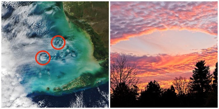
NASA space photo shows odd-looking sky holes near Florida
These sky holes can be seen from the ground and in space. They're called cavum clouds and have a scientific explanation.

NASA Earth Observatory image by Michala Garrison, using MODIS data from NASA EOSDIS LANCE and GIBS/Worldview
- A NASA satellite snapped a photo of giant ring-shaped clouds over the Gulf of Mexico.
- You can see this phenomenon, called cavum clouds, from the ground and in space.
- Cavum clouds have a natural explanation but have been mistaken for aliens and other odd phenomena.
Earlier this year, NASA's Terra satellite was zipping over the Gulf of Mexico when one of its instruments snapped a photo of some odd-looking clouds.
The clouds looked like someone had taken a hole punch to the sky.
This unusual phenomenon isn't new. Researchers have been documenting it since the 1940s, according to NASA. But it wasn't until about 15 years ago that scientists finally found an explanation.
The features are officially called cavum clouds, but are sometimes nicknamed hole-punch clouds or fallstreak holes. They're so big that you can see them from the ground and in space.
From the ground, they can look like this: pr2is/Getty Images
It's no wonder that people have mistaken them for flying saucers or other unusual phenomenon. They don't look like your average cloud.
And, in fact, they aren't your average cloud. If it weren't for human technology, cavum clouds would never exist.
They form when airplanes fly through banks of mid-level altocumulus clouds — clouds made of supercooled droplets — according to a pair of studies published in 2010 and 2011.
Researchers from NASA's Langley Research Center found in 2010 that the more shallow the angle that the plane takes to pass through the clouds, the larger the cavum left behind will be.
The analysis showed that any type of plane can produce cavum clouds.
NASA's Terra satellite captured photos of a "cluster" of cavum clouds near the west coast of Florida on January 30. The more than 1,000 flights per day coming from the Miami International Airport are a major contributor to the phenomenon, according to the agency.
The Terra satellite is designed to study changes in Earth's atmosphere and the effects of climate change. Researchers use data collected from the satellite to map the impact of human activity and natural disasters.
What's Your Reaction?


