L.A. Isn’t Ready for What’s Next
Sooner or later, a winter storm will hit, and deadly mudslides and debris flows that will likely follow.

As firefighters struggle against the blazes in Southern California, onlookers have been hoping and praying for rain. But anything more than a drizzle risks setting off terrifying new natural disasters. After steep hillsides burn, a rainstorm is likely to trigger flash floods, mudslides, or debris flows. The threats to life and property are dire. State and local officials in California are rushing to study land that has burned, identify where trouble is likely when it next rains, and warn residents. But more time is needed to complete their work. And there are limits to what their models can predict.
Jason Kean, a research hydrologist with the U.S. Geological Survey’s Landslide Hazards Program, talked me through the coordinated effort to figure out who is in peril.
The first step is comparing infrared satellite images of greater Los Angeles taken before and after the fires, to map the most badly burned parts of the landscape. Most concerning are moderate or severe burns on steep slopes. Analysts plug data on burn severity, slope pitch, and soil composition into computer models that show how those areas are likely to react to rainstorms of different strengths. The results are sent back to teams that identify dwellings and businesses in harm’s way. The National Weather Service will then track storms in the at-risk areas that could set off a disaster. The worst-case scenario is an intense burst of rain over a hillside burn area.
[Read: What happens when a plastic city burns]
Identifying steep slopes denuded of vegetation by wildfires is relatively straightforward. So is tracking a storm that’s headed for such an area and issuing public warnings. But those warnings are imperfect. If a hillside most at risk of collapse does give way, along what path will the debris flow? And where will it wind up? Knowledgeable experts can make educated guesses but are ultimately unsure. “Maps showing potential paths of debris would be ideal for defining evacuation zones, but that’s a missing piece in our current model,” Kean explained. “We have been scrambling to fill that gap, and we’re close, but we aren’t quite operational.”
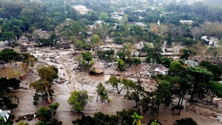
The consequences of incomplete knowledge can be catastrophic, as a recent disaster illustrates. In a wildfire that began in December 2017, 282,000 acres near Santa Barbara burned. On January 8, 2018, before the fire was extinguished, a rainstorm arrived, prompting emergency warnings. In the wee hours of January 9, half an inch of rain fell on the Santa Ynez Mountains in perhaps 15 minutes. That rainfall led to more death and destruction than the fire itself.
Imagine an Olympic-size pool perched high on a mountainside. It is filled with mud, rocks, sand, tree branches, and boulders, some bigger than 20 feet in diameter. If you spilled its contents, it would flow downhill, gathering mass all the while, as fast as 20 miles an hour. That morning, the actual debris flow caused by rain was the cubic volume of 272 Olympic-size pools. Gravity pulled the debris nearly two miles downhill. Montecito, a town where thousands of people live, was in its path. Twenty-three people were crushed to death, many while sleeping; 167 were injured; 408 homes were damaged. Highway 101 was covered in mud. In some places, the mud was 12 feet deep, nearly reaching overpasses. Even officials who understood that intense rainfall in a burn area could displace that much debris were shocked by the degree of death and damage.
The Montecito disaster is on the minds of local, state, and federal officials as they evaluate burn areas in Los Angeles today. When Kean and I spoke on Tuesday, teams were out trying to produce initial burn-severity maps as quickly as possible––January and February are typically the rainiest months in Los Angeles––but their work has been slowed and complicated by the fact that the fires are all still burning.
Angelenos many miles from a burn area, or living near one but at higher elevations, aren’t at risk. But those who live near a burn area and at a lower elevation than it may be at risk, especially when in an affected canyon or near a flood-control channel or a street that regularly floods.
[Conor Friedersdorf: How Los Angeles must rebuild]
Some precautionary measures, such as putting out sandbags and boarding up sliding glass doors, can harden their homes against increased flooding and minor mudslides, but debris flows are different.
In The Control of Nature, the writer and geology buff John McPhee described what happened when an unexpected debris flow surged into a family house in California: “The dark material … was not only full of boulders; it was so full of automobiles it was like bread dough mixed with raisins. On its way down Pine Cone Road, it plucked up cars from driveways and the street. When it crashed into the Genofiles’ house, the shattering of safety glass made terrific explosive sounds. A door burst open. Mud and boulders poured into the hall … The debris flow, entering through windows as well as doors, continued to rise.” All survived, but just barely. They should have evacuated.
What's Your Reaction?


