Hurricane Beryl Is a Terrifying Omen
This season’s first major storm broke records. How bad will the rest be?

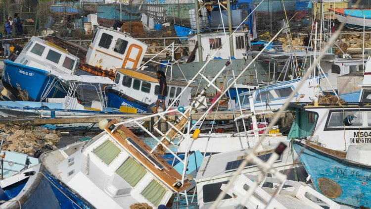
Hurricane Beryl is an unprecedented storm. It’s been nearly 174 years since certain parts of the Caribbean have experienced a storm this brutal. Over just a few days, Beryl has ripped through the region, leaving devastation on the islands in its path. The doors and roofs have been torn off homes. Trees have been snapped in half and branches thrown into the street. Cows have been killed in the fields where they grazed. At least six people have died in the storm, and officials expect the number to rise. According to the prime minister of Grenada, the Category 4 hurricane "flattened" the island of Carriacou, where it made landfall yesterday, in just half an hour. And that was all before Beryl leveled up to Category 5 last night, reaching wind speeds of 165 miles an hour.
Beryl transformed from a tropical depression to a Category 4 hurricane in two days, faster than any hurricane has ever done before the month of September, Brian McNoldy, a senior research scientist at the University of Miami, told me. It is the easternmost hurricane to emerge in the tropical Atlantic Ocean in the month of June. It’s the first storm to strengthen to Category 4 in the Atlantic in June, and now the earliest on record to hit Category 5. Hurricane Beryl “is not normal, in any way, shape, or form,” Ryan Truchelut, a meteorologist in Tallahassee, Florida, who runs the consulting firm WeatherTiger, told me.
We’re only a month into the Atlantic hurricane season, and already, the boundaries that normally govern it are breaking. The cause is abnormally hot ocean waters—warmed by El Niño last year, but also by centuries of burning fossil fuels. Climate change “does not make a storm like Hurricane Beryl exist, but it certainly helped,” McNoldy said. Monster hurricanes like Beryl shouldn't happen this early. They shouldn't arise in this particular part of the Atlantic basin. And they shouldn't be intensifying at such astonishing rates, before the season has even gotten into full swing. But they are, and will probably continue to do so as long as our oceans continue to simmer.
[Read: The oceans we knew are already gone]
Experts have been warning of unusual events like Beryl for weeks now. Global sea-surface temperatures have been historically high for more than a year, and warm water provides plenty of moist air that fuels storms as they move along. In May, the National Oceanic and Atmospheric Administration predicted an extraordinary season of eight to 13 hurricanes, compared with the usual seven. Between four and seven of those could count as major, between Category 3 and 5. A typical season sees only three.
Beryl’s dramatic arrival echoes some of the nastiest moments in Atlantic hurricane history. The previous record for easternmost tropical Atlantic hurricane was set in 1933, which saw six major hurricanes. The season in which a Category 5 storm took shape earliest was 2005, the year of Katrina, Rita, and Wilma. “Those two years are not years you want to be breaking records of,” McNoldy said. “Those are the two most scary, active hurricane seasons that have ever been observed.” According to the Colorado State University meteorologist Phil Klotzbach, as of this afternoon, Beryl has generated more energy than 1983’s entire, quiet season.
All of this is particularly startling when you consider that Beryl is only the first hurricane of the season, which usually peaks in mid-September. Right now, the Caribbean Sea is as hot as it typically is in late August and September—how much warmer will it be in two months? Plus, forecasters’ dire predictions for this hurricane season are heavily influenced by La Niña, El Niño’s cooler opposite, which also allows hurricanes to become stronger than they otherwise would. But La Niña isn’t even here yet. It’s expected to arrive later this summer. “I don’t see any reason why we shouldn’t expect more high-end events to happen this year,” McNoldy said. The strongest, most destructive storms are still yet to come.
[Read: ‘La Niña really can’t come soon enough’]
Experts had anticipated a storm as extreme as Beryl, but they’re still awed when faced with the real thing. “Everybody in tropical meteorology is just shocked by this,” Truchelut said. And if ocean warming continues apace, more people may soon find themselves similarly shocked. Beryl is a horrifying reminder that, in a warmer world, more people live in the path of potentially catastrophic storms.
Beryl is now traveling across open water toward the central Caribbean. It’s predicted to weaken today while bringing still-dangerous winds and storm surge to Jamaica, the Cayman Islands, and southwestern Haiti. Then it will likely make landfall again along Mexico’s Yucatán Peninsula later this week. By the time it is forecast to reach Texas’s Gulf Coast over the weekend, it should be a rainy tropical storm—a relatively minor threat for a region that is used to major hurricanes, if not ones that come so early.
In this hurricane season, and those to come, even people who live in regions that experience storms every year will need to recalibrate their approach. A grizzled Texan or Floridian might say they haven’t had to evacuate in decades. But hurricanes are fundamentally changing. Americans seem to have escaped this nightmare storm, but “we might not be so lucky next time,” Truchelut said. “The next one might be pointed at the southeastern United States.”
What's Your Reaction?


